The technologies we use to optimize site data collection, design, and safety in our day-to-day work have taken on additional value these days. While critical in the fight against COVID-19, social distancing measures and travel restrictions present unique challenges to our clients and colleagues in the field. Despite these challenges, our clients’ time-sensitive needs haven’t slowed, so we are leveraging this suite of tools to help maintain continuity and compliance while reducing risk. I have been impressed with how quickly and creatively our colleagues deployed these remote technology tools to keep projects moving forward.
3-D Cameras and Scanners Optimize Site Data Collection and Design
3-D cameras and scanners allow users to create digital, 360-degree walkthroughs of spaces. Woodard & Curran offers this technology — specifically a Matterport Camera — to our teams and clients to recreate spaces digitally, allowing us unlimited access to project site information throughout the design process. The point-cloud photogrammetry generated by this tool provides accurate interactive measurement data and serves as the basis for modeling in our intelligent design software platforms.
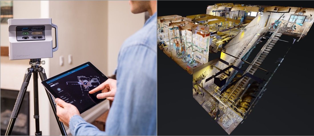
These comprehensive, interactive renderings allow us to reduce potential design and construction conflicts. We are better able to design solutions for our clients in the context of existing project environments, with fewer — and in some cases no — physical site visits. This tool has proven time efficient, cost effective, and more thorough and accurate than traditional camera photography and field measurements. Documentation of existing as-built conditions that might have taken multiple days are being accomplished more accurately in a matter of hours by a single user equipped with this technology. These 3-D environment renderings are also beneficial to clients for virtual inspections, asset documentation, and emergency response planning.
Real-time Site Access from a Distance
Our colleagues serving our municipal water clients and environmental projects are leveraging select Microsoft Dynamics 365 technologies to provide on-site expertise from afar. We have used Microsoft’s Remote Assist Mobile on several sites where traditionally, a Woodard & Curran employee would make a physical visit, interact with client stakeholders, and perform an inspection. We are still conducting these types of site investigations with careful compliance with travel restrictions and required social distancing measures, but these remote access tools provide a time- and cost-efficient alternative while reducing personal contact on site.
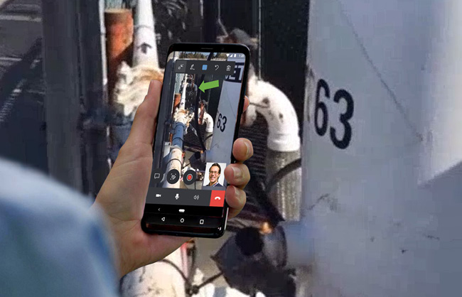
Remote Assist Mobile is a unique collaboration platform that allows our experts, with the help of essential on-site personnel, to conduct visual inspections via video call with most mobile devices. What differentiates Remote Assist from other video platforms is a suite of interactive elements allowing the remote user to overlay graphic elements, better pinpointing areas of concern or providing more distinct instructions. Remote Assist Mobile is a relatively easy-to-use, low-cost option to provide users on site with real-time access to remote support staff.
Remote Assist is also available with Microsoft’s Hololens headset, a mixed-reality smart-glasses device resembling a VR headset. These devices are worn by on-site field personnel and allow remote support staff to see through the technician’s eyes to help with tasks, share remote images, pull up technical data, or add graphic elements to the user’s line of vision. Remote Assist Hololens provides many of the same benefits as the mobile application but allows the field technician to bring in multiple collaborators simultaneously, operate the system with voice activated controls, and work hands free as the remote support staff are able to discuss and overlay important information in real time.
Safer Inspections in Hard-to-Access Locations
Safety is a core Woodard & Curran value and our teams consider safe work practices their highest priority. Public works employees and treatment facility staff frequently need to inspect hard-to-reach locations prior to and during maintenance, asset management, repair and construction work; and they embrace tools and technology that can minimize risk in these day-to-day responsibilities maintaining infrastructure. For Operations & Management, GoPro or similar video cameras are helpful to visualize assets that are otherwise difficult to access or require larger teams to conduct safe entry procedures.
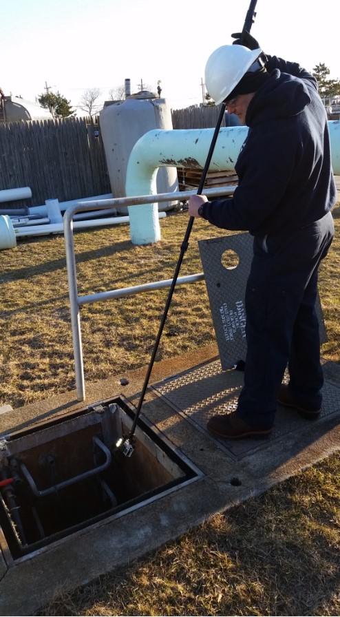
These cameras are small, capable, versatile, and robust digital video recorders. With no viewfinder or screen, this technology manages to fit numerous practical, high-value features into a small device. Most importantly they feature water, drop, and dust resistance that allow them to hold up to a wide range of challenging conditions encountered in the field. Camera manufacturers also offer a slew of mounts and accessories that broaden the cameras’ applications. Our operators typically work in pairs — one maneuvering the camera on a stick mount, and another viewing and navigating via a connected mobile device — to capture video for confined-space inspections, pre-entry assessments, above- and below-ground equipment observations, and more.
Covering More Ground with Drones
Drones are advanced, multipurpose remote technology. Able to go where human access may be limited or difficult to achieve safely, we utilize drones to efficiently find, map, and inspect infrastructure, buildings, and terrain. Drones allow us to mitigate and sometimes eliminate health and safety risks encountered while working near busy roadways, waterways, at height, within unique infrastructure, or in and around unstable, varying, or environmentally sensitive terrain. A drone can perform visual inspection in real time with the camera acting as an inspector’s eyes and the recordings used for documentation, analysis, and design. Drones can also be equipped with various specialty sensors or equipment for particular needs such as providing orthoimagery, 3-D scanning and modeling, surveying for contours and volume calculations, thermal imaging and almost any other data recording technology that can be fitted to the unit. One of the advantages of employing drones is the ability to survey large areas in a short period of time.
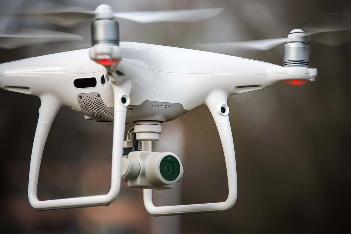
Drones may not be a viable option for every application, but we have experience assessing site conditions, constraints and project objectives to determine feasibility technology selection. Drones require an investment in equipment, training, and certification, and Woodard & Curran employs six FAA-licensed drone pilots who navigate our company-owned remote aircraft in accordance with the FAA Code of Federal Regulations Part 107. Our pilots are strategically located in various regions of the United States and support drone applications such as high-resolution orthophotos, topographic mapping, 3-D modeling, and thermal inspections.
Want to know more?
In May, Client Manager Erika Lloyd presented this webinar on our remote capabilities. Have questions about applying these technologies to achieve your compliance, safety, and business continuity needs? Contact us.
