According to recent census data, nearly 30 percent of the United States population lives in coastal areas. Homes, businesses, utilities, transportation, habitat, landfills, and hazardous waste sites in these densely populated coastal areas are at risk with each king tide and storm surge. Flooding from such events is now up to nine times more frequent than it was 50 years ago, according to National Oceanic and Atmospheric Administration (NOAA) data. In January, the California Ocean Protection Council (OPC) released a draft report, projecting sea level rise as high as 1.2 feet by 2050 and 6.6 feet by 2100 greatly impacting the state’s coastline. On the East Coast, Maine Climate Council predicts sea level rise as high as 3.2 feet by 2050 and 8.8 feet by 2100. Converging with increased flooding from coastal inundation, changes in precipitation patterns and lost drainage capacity at coastal outfalls create added risk, which is most severe along shorelines where local drainage collects. However, system backups can cause impacts farther and farther inland.
As coastal communities continue to experience severe weather and flooding, there is an increased risk to public health and safety, interruptions in utility services, and economic loss due to emergency repair costs, business downtime, and tax revenue. Such impacts are felt not only locally, but across the wider region served by impacted infrastructure networks. While mitigation efforts will not eliminate risks completely, such work is up to six times less expensive than recovery from disaster and there is a growing need for communities to develop adaptation roadmaps that reduce risks. It can be daunting to start with large-scale adaptation projects along shorelines and waterways, but our communities can’t afford to let perfection be the enemy of a good and actionable plan.
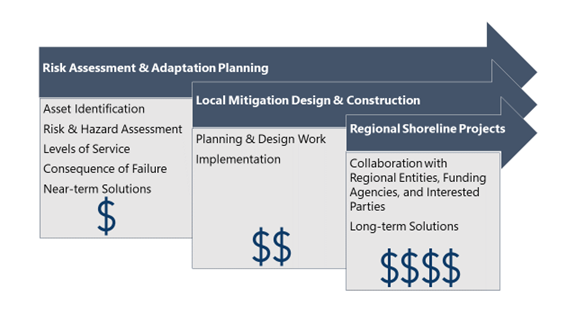
Parallel Pathways to Adaptation
At Woodard & Curran, we encourage our clients to start by assessing local infrastructure risks due to climate change, sea level rise, and combined flooding to identify ways to make assets more resilient. Understanding risks provides information necessary to build consensus around action. A clear articulation of plan objectives, potential impacts, and the cost of inaction provides context for the cost of plan implementation that can help build support and attract funding for next steps. It also provides a baseline understanding of how to best invest time and money in resiliency efforts. A solid plan leverages relatively small amounts of funding to create a vision for success and lay a foundation that justifies further expenditures, explains return on investment, and clarifies the need to fill gaps in understanding, partnership, and funding for future steps. Actionable assessments can identify both near-term and long-term solutions so that work can proceed on advancing both paths in parallel.
During initial planning, clients should develop and refine a list of key assets, define levels of service and consequences of failure, and estimate the cost of inaction. Additionally, a range of potential hazards should be considered, specific to the types of assets at risk from sea level rise, potential for increased wind-wave action, altered rainfall intensity, combined flooding and emergent groundwater, salinity intrusion, and other impacts to both surface and buried infrastructure. Understanding of these impacts will likely evolve over time due to advances in climate change science and increasing certainty of climate outcomes as projection timeframes near. However, a solid understanding of risk tolerance at the outset, and identification of opportunities for adaptive management mitigate these concerns, allowing confidence in near-term actions.
Near-term solutions often focus on identifying risk reduction measures for local assets that are at the highest risk and within the asset owner’s immediate control. Such solutions may include elevating electrical and at-risk assets already at or near the end of their useful life, adding wet or dry floodproofing, increasing system capacity and redundancy, implementing localized drainage solutions, or installing floodwalls or levees around low-lying assets. These types of projects offer the opportunity to provide an early win that can build confidence in the plan’s ability to deliver risk reduction. These projects also typically do not require cross-jurisdictional collaboration with other utility operators or municipalities and are relatively easy to implement. However, successful near-term adaptation measures should occur within the framework of an overall adaptation roadmap to avoid costly rework in the future and optimize investment. This initial roadmap may be imperfect in its formation, but can still provide a basis for larger discussions with regional partners, funding agencies, engineers, and design teams. It also provides a touchpoint to building political will behind larger, complex long-term solutions.